English summary - LIFE Floodplain Development
One of the two key objectives of this project in the floodplains along the river IJssel is to enlarge the area of characteristic riverine Natura2000-habitats and with that to create biotopes for species associated with these habitats.
Nature Development
in the upper flood plains of river IJssel
Project objectives
Together the upper flood plains of the river IJssel are called IJsselpoort. IJsselpoort is also the name of the project area of this LIFE-project. The area consists of two subareas, being the relevant parts of the floodplain areas Koppenwaard and Velperwaarden.
One of the two key objectives of this project in the floodplains along the river IJssel is to enlarge the area of characteristic riverine Natura2000-habitats and with that to create biotopes for species associated with these habitats. This objective goes hand in hand with the other key objective: to improve the water safety by buffering and preventing the effects of climate change (e.g. high flood risks, but also drying out). The LIFE-project is a part of the more extensive project Rivierklimaatpark IJsselpoort that aims at a future-proof, climate change adapted spatial development in the upper floodplains of the river IJssel. Besides the two key objectives the project aims at improvement of the public accessibility and recreational zoning, extension of the recreation facilities and involvement of local farmers in the (future) habitat-oriented management.
Habitats
The project area and many other parts of the floodplains along the river IJssel participate in Nature2000 because of the presence of large areas of several threatened habitats and species.
Important habitats, which are also the target habitats of this project, are:
- Natural eutrophic lakes with Magnopotamion of Hydrocharition-type vegetation (H3150)
- Rivers with muddy banks with Chenopodion rubri p.p. and Bidention p.p. vegetation (H3270)
- Xeric sand calcareous grasslands (H6120*)
- Lowland hay meadows - Alopecurus pratensis, Sanguisorba officinalis (H6510)
- Allucial forests with Alnus glutinosa and Fraxinus excelsior - Alno-Padion, Alnion incanae, Salicion albae (H91E0*)
- Riparian mixed forests of Quercus robur, Ulmus laevis and Ulmus minor, Fraxinus excelsior of Fraxinus angustifolia along the great rivers (Ulmenion minoris)(H91F0).
Of these habitats the very local and both on an international and national level threatened habitat Xeric sand calcareous grasslands (H6120*) is denoted as priority habitat. This also applies to the habitat Alluvial forests with Alnus glutinosa and Fraxinus excelsior - Alno-Padion, Alnion incanae, Salicion albae (H91E0*).
Target species
Target species of the project are, among others:
- spotted crake (Porzana porzana, A119)
- corncrake (Crex crex, A122)
- black tern (Chlidonias nigra, A197)
- kingfisher (Alcedo atthis, A229)
- sand martin (Riparia riparia, A249)
- bluethroat (Luscinia svevica, A272)
- beaver (Castor fiber, H1337)
- crested newt (Triturus cristatus, H1166)
- natterjack toad (Bufo calamita, H1202)
- European weather loach (Misgurnus fossilis, H1145)
- spined loach (Vobitis taenia, H1149)
- sea lamprey (Lampetra planeri, H1095)
- river lamprey (Lampetra fluviatilis, H1096)
- European bulhead (Cottus perifretum, H1163)
- European bitterling (Rhodeus amarus, H1134)
- brown argus (Aricia agestis)
On the long-term species like otter (Lutra lutra), black kite (Milvus migrans), black stork (Ciconia nigra) and white-tailes eagle (Haliaeetus albivilla, A075) can be expected.
Carrying out this project will highly contribute to the enlargement of the area of the target Natura2000-habitats and will increase the possibilities for many species associated with these habitats.
The project is strongly linked with other nature development projects along the river IJssel conducted in the past two decennia or in the near future. After project finalisation the habitats will be better connected with habitats in other nature areas located further downstream. By the dispersion possibilities of target species is enhanced, ultimately resulting in increasing populations.
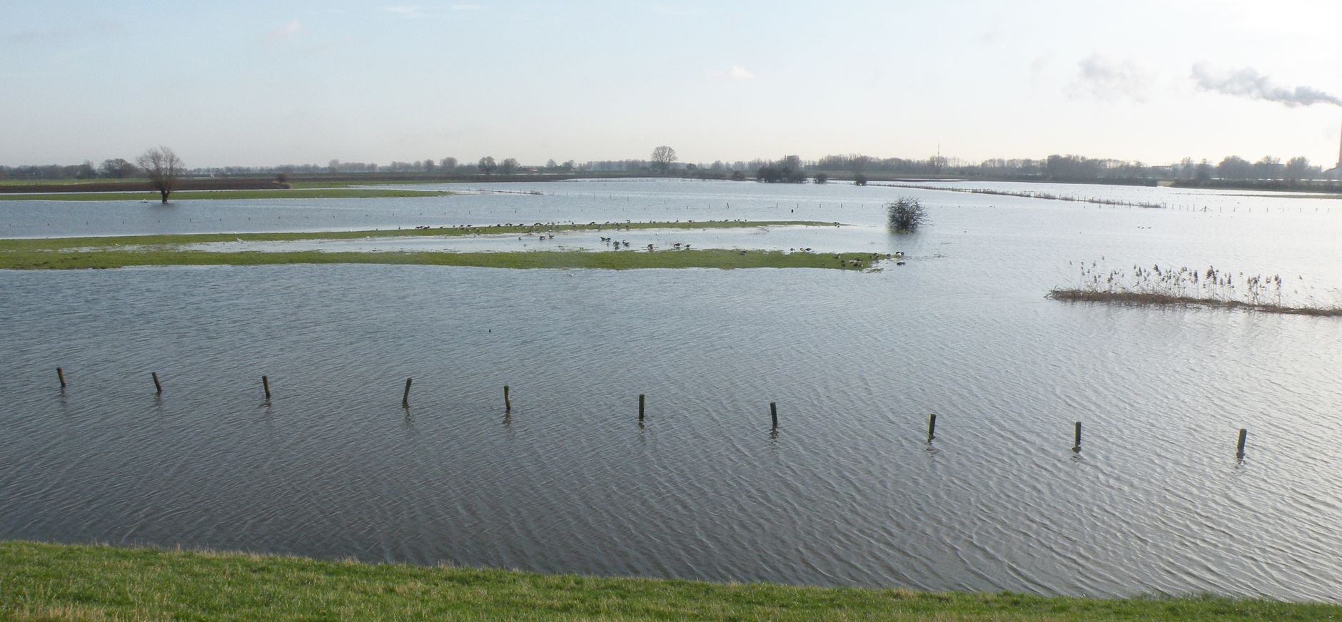
Over centuries the natural dynamics of the river IJssel decreased through extensive river normalisation and embankment measures. These measures caused direct habitat loss and decreasing poulations or even the complete disappearance of associated pecies. Up till now there is little chance for many habitats to develop again because of lack of (freedom for) natural processes like sedimentation and erosion.
Furthermore the floodplains of the IJssel came into agricultural use for a large part. Continous agricultural intensification and overfertilisation resulted in a more and more monotonous landscape with low nature values and high euthophication. As a result of the disappearance of many more or less natural habitats along the river IJssel populations of many plant and animal species are highly fragmented. Now the often small populations persist in small relicts of formerly widespread habitats. The relicts are very vulnerable to become extinct. The presence of forest habitats in the floodplains of the IJssel is limited because forests do not fit the presence policy on water safety and river transport because they hamper the flow of river water.
River normalisation measures, current policies on water safety and agricultural intensification have left little space for habitats and species. As a consequence many of the important habitats and associated species and target habitats and species of this project are currently under serious threat.
The current land use of the subareas Koppenwaard and Velperwaarden is mainly agricultural. A significant part of the Koppenwaard subarea is formed by a brickstone factory that is out of use.
As a result of the current land use in the project area the nature values are low up till now. Nevertheless the project area is important for some habitats and certain species of flora and fauna. The existing Xeric sand calcareous grassland (H6120*) in the Velperwaarden subarea is both on the national and international level very important. The majority of the Xeric sand calcareous grasslands (H6120*) in North-western Europe can be found in the Netherlands. In the Netherlands the habitat only covers 30 hectares of good quality and in total 100 hectares at the very most. The area of the habitat has been severely reduced in the last centuries as a result of river normalisation measures, sand extraction, residential building and agriculutral intensification.
Among the many species of breeding birds in the project are the Birds Directive species stonechat (Saxicola torquata, A224), kingfisher (Alcedo atthis, A229) and formerly corncrake (Crex crex, A122). However, from an avifaunistic point of view the area is primarily important for non-breeding bird species and especially water birs like waders, ducks and geese. Observed fish species in the river IJssel and Rozendaalse Beek include the Habitat Directive species sea lamprey (Lampetra planeri), river lamprey (Lampetra fluviatilis) and European bullhead (Cottus perifretum). The project area is also important for amphibians like natterjack toad (Bufo calamita, H1202).
Actions and means involved
In order to reach the objectives land purchase of areas that are currently in agricultural use forms a crucial part of the project. In total 65 hectares will be purchased, 17 hectares in the Koppenwaard and 48 hectares in the Velperwaarden.
Following the land purchase nature development measures will be carried out. The performed nature development measures are, among others:
- digging of the top soil in order to lower the ground level and to create open water
- digging of existing clay pits to prevent them from drying out
- creation of a marshy zone along the small stream Rozendaalse Beek
- restoration of the characteristic hedge pattern by planting (mainly hawthorn).
Besides of the measures that focus on the habitats the improvement of recreation facilities and recreational zoning is an important part of the project. Enhancing the accessibility of the project area for the public will enlarge the regional support for the project. The measures for visitors consist of the building of a bird observatory (including entry path), placing wooden benches at viewpoints, restoration and extension of a footpath (subarea Koppenwaard) and shortcuts to the river IJssel.
After the project period the results of the preceding actions will be continued and guaranteed by setting up a proper continuation management. This management mainly consists of grassland management by grazing with cattle of local farmers and/or mowing. Management not performed by farmers can be carried out by contractors, own employees of Natuurmonumenten and/or volunteers. Management of forests is limited to mowing and interplanting of perishing trees and shrubs in the primary stage of development. Alluvial forests are expected to develop by natural generation.
Expected results (outputs and quantified achievements)
The target habitats cover an area of in total 104 hectares. Of this area 9 hectares already comprise the targeted habitat and only land purchase is applicable here to safeguard the habitats for the future. The area of target habitats increases with about 95 hectares after implementation of the project. In the case of the habitats Xeric sand calcareous grasslands (H6120*) and Lowland hay meadows - Alopecurus pratensis, Sanguisorba officinalis (H6510) respectively 9 hectares and 40 hectares will develop by grazing and/or mowing management after the land purchase. No active measures (C-actions) are carried out here. For a large part this management will take place after the project period.
The added areas per habitat are:
- H3150: 19,5 ha
- H3270: 4 ha
- H6120: 10 ha
- H6510: 66,5 ha
- H91E0: 3 ha
- H91F0: 1 ha
In total: 104 ha
Above mentioned hectares per habitat are approximate. The exact areas that will be realised depend on the outcome of the detailed plan that will be made before the start of execution of the nature development measures.
From the perspective of water safety and climate change the measures increase the water storage capacity in the floodplains and thus reduce the risk of flooding elsewhere. Furthermore, the measures prevent habitats from drying out during summer. Finally, the measures improve the spatial connection of habitats and populations of species that are susceptible to climate change.
The recreational measures result in a bird observatory, a partly restored and extended footpath (Koppenwaard), shortcuts to the river IJssel and other improved facilities for visitors (e.g. wooden benches at viewpoints).
Both the present situation and the impact of the restoration actions will be determined by monitoring. The monitoring data can also be used to evaluate and, if necessary, adjust the management. The monitoring of flora consists of a survey on (Natura2000) target species and species of the Dutch Red List. Fauna monitoring to the conducted includes breeding and non-breeding birds, amphibians and fish. Abiotic data on floodplain heights, sedimentation/erosion, water quality and water levels of the river IJssel are obtained from Rijkswaterstaat through their long-lasting monitoring network.
Climate change adaptation project
This LIFE-project gives concrete shape to the realisation of the more extensive project Rivierklimaatpark IJsselpoort. Rivierklimaatpark IJsselpoort aims at a future-proof, climate change adapted spatial development in the upper floodplains of the river IJssel by buffering and minimising the effects of climate change.
From the viewpoint of water safety and climate change adapted management the execution of this LIFE-project increases the water storage capacity in the floodplains and thus reduce the risks of flooding elsewhere. Furthermore the measures prevent habitats from drying out during summer. Finally, the measures improve the spatial connection of habitats and populations of species that are susceptible to climate change.
Life, NPL
